Heavy precipitation events (HPEs) pose a threat to human lives as well as the economy and the environment of impacted regions. HPEs occurring in small and steep watersheds are responsible for the triggering of flash floods with a sudden and often violent onset and rapid rise of rivers, typically from 1 to 6 h following the causative rainfall. Flash floods and landslides lead to fatalities, loss of crops and livestocks, damage to infrastructures, as well as disruption of transport and communication. HPEs remain difficult to predict. Considerable efforts to improve the forecast skill for such severe events have been made in recent years and significant progress has been realized through the development of kilometer-scale numerical weather NWP systems and data assimilation techniques. However, our ability to predict such high-impact events remains limited because of the lack of adequate high frequency, high resolution vertically resolved water vapor (WV) observations in the lower troposphere to be assimilated in NWP systems, and especially in the planetary boundary layer. The implementation of an integrated prediction tool, coupling network measurements of WV profiles and a NWP model, to precisely estimate the amount, timing, and locations of rainfall associated with HPEs up to 48 hours in advance, is a strong societal demand, especially in regions of France most exposed to heavy rainfall (defined as maximum accumulation in excess of 150 mm per day) as those located along the Mediterranean coast.


As part of the WaLiNeAs initiative, the WV Raman lidars will be operated continuously during 3 months starting early September 2022, to cover the period most propitious to HPEs in southern France. The duration of the operation is imposed by the necessity to have a long enough record in order for the WV profiles assimilated to have a significant impact on the moisture fields in the model forecasts. This long dataset is crucial to assess statistical errors and to genuinely evaluate the benefit of Raman lidar water vapor data assimilation for operational NWPS.

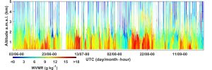
Raman lidar-derived water vapor mixing ratio profiles collected up to 4 days ahead of high precipitation event (HPE) are significantly moister than for a 4-day period when no HPE events occured in Southern France, thereby providing data worthy of assimilation in a HPE forecasting context.
The WaLiNeAs field campaign took place in 2 phases: a first phase during the autumn/winter of 2022-2023 at the Coursan, Cannes and Le Grau-du-Roi sites and a second phase during the summer of 2023 in Toulouse. The WALI, HORUS-1 and HORUS-2 lidars were deployed during these campaigns.
During WaLiNeAs, various meteorological events were sampled by the lidars, including Saharan dust events, thunderstorms and extreme heat.
The presentation of the instruments and the processing of the lidar data were the subject of the following publication: https://doi.org/10.5194/essd-2024-73, 2024.
Weather maps of the Mediterranean basin during the WaLiNeAs period
In this section, you will find meteorological maps of various atmospheric parameters plotted using ERA5 reanalysis (https://cds.climate.copernicus.eu/datasets/reanalysis-era5-pressure-levels)