Lidar observations are the only means to reproduce highly resolved vertical profiles of key atmospheric parameters such as water vapour content, temperature, aerosols, and clouds. They also have great potential for determining vertical profiles of greenhouse gas concentrations at an unprecedented vertical resolution, leading to better source apportionment.
One of the current challenges for improving weather forecasts and climate projections is to have permanent observation resources of the main atmospheric actors at different scales. Two complementary approaches are being implemented by the international scientific community: the construction of ground-based observation networks and the development of specific spaceborne missions. Space observations have already demonstrated their potential for operational meteorology, which relies heavily on the assimilation of measurements from passive instruments such as the IASI Fourier transform spectrometer. The limitation of this type of observation is linked to the difficulty of sampling the lower troposphere, which includes the planetary boundary layer. A solution is to try a synergy between remote sensing instruments on-board satellites and complementary ground-based sensors performing measurements with increased vertical and temporal resolutions, such as lidars.
Field campaigns simultaneously allow the study of processes that are not yet mastered and to enhance the value of observations that combine different instruments and platforms. Atmospheric water vapour, aerosols and clouds are three of the actors that are measured in the framework of such field campaigns.
Water vapour acts as an ‘amplifier’ of the warming associated with greenhouse gases, doubling the surface warming associated with atmospheric CO2. Its concentration can vary by three orders of magnitude in the troposphere and its spatio-temporal variability is closely linked to vertical motion, surface evaporation and precipitation. The increase in the surface temperature of the oceans also induces an increase in evaporation, and thus amplifies the latent energy reserve which is responsible for the increase in the intensity of extreme meteorological phenomena (feeding of convective systems), the societal impacts of which have been clearly established (e.g. the intensification of the Cevenol phenomena). The role of water vapour is therefore fundamental in meteorology, as it is in climatology. Its cycle in the atmosphere is strongly coupled to those of clouds and aerosols. Hence, simultaneous measurements by lidar of atmospheric temperature, water vapour content, and aerosol/clouds structural and optical properties are fundamental to improve our knowledge of these coupled atmospheric cycles. The existing links between these cycles are still poorly understood, not only in processes leading to extreme weather events, but also in climate projections.
Atmospheric aerosols and clouds interact with solar and terrestrial radiation, thereby directly or indirectly influencing the Earth system’s climate. Anthropogenic aerosols also play a significant role in air pollution, impacting the health of animals and plants. The WHO estimates that 1.4% of deaths worldwide are caused by particles in the atmosphere.
For this reason, French research organisations such as the CNRS and the CEA have led the project to develop lidars. These lidars primarily enable the monitoring of water vapour, temperature, and aerosol and cloud profiles in the lower and middle troposphere, either from the ground or from aircraft. They are involved in various field campaigns. This new generation of instruments is unique in the French scientific landscape.
These different instruments have acquired data that may be of interest to the international scientific community. This data is made publicly available here for various field experiments.
News
Lemon field campaign
Lidars are used to measure the concentration of water vapour in the lower troposphere, where the lack of information does not allow to sufficiently constrain the prediction of extreme precipitation events. Two innovative lidar technologies are developped and deployed, one based on inelastic Raman scattering and the other one on differential absorption through the atmospheric […]
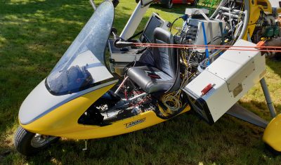
Airbone aerosol Raman lidar
Few airborne aerosol research experiments have deployed N2-Raman lidar despite its capability to retrieve aerosol optical properties without ambiguity and help to identified the atmospheric vertical strutures. It is possible by using specific flight plans and appropriate algorithmic approach, aiming to solve the notorious instability of the airborne lidar inversion. One of the fundamental vertical […]
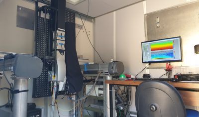
Water vapor Raman Lidar
The increasing importance of the coupling of water and aerosol cycles in environmental applications requires observation tools which allow simultaneous measurements of these two fundamental processes for climatological and meteorological studies. For this purpose, a new mobile Raman lidar, WALI (Water vapor and Aerosol LIdar), has been developed and implemented within the framework of the […]